National Hurricane Center Watching 2 Areas For Tropical Development
Hurricane Season Ramps Up Now — What To Know
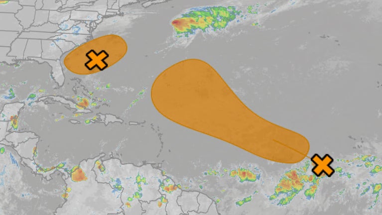
The National Hurricane Center has their eyes on two areas for possible tropical development in the Atlantic Basin beginning late this week after Tropical Storm Dexter fizzles.
Area #1: Near Southeast US Coast
– Low pressure is expected to form along an old stationary front off the Southeast coast in a day or so.
– It could then drift slowly north before turning northeastward and out to sea. If it develops enough thunderstorms, it could become a tropical depression or storm late this week or this weekend.
Weather in your inbox
– Depending on how close that low gets to the coast, it could bring rounds of showers with locally heavy rain. Regardless of development, however, scattered thunderstorms are expected in the Southeast from the Carolinas to Georgia and Florida through the weekend.
– High surf and rip currents are possible along much of the East Coast late this week through the weekend, especially from the Delmarva Peninsula to North Carolina.
(MORE: How To Spot And Survive A Rip Current)

Tropical Development Potential
Area #2: Eastern Atlantic
– An area of lower pressure called a tropical wave is in the far eastern Atlantic Ocean, popping some disorganized showers.
– It has some initial dry air to fend off in its path, but it could develop into a depression or storm by this weekend east of the Lesser Antilles.
– Its future beyond that is uncertain, with model forecasts ranging from two general scenarios:
1. Development sooner and a northward curl harmlessly into the central Atlantic by early next week.
2. The wave struggles to develop and continues toward the west-northwest, potentially developing mid-late next week closer to the Caribbean or Bahamas.
The first scenario is most likely at this time, but it’s too soon to rule out the second scenario that could bring impacts to land next week. Check back with us at weather.com for updates.
(MORE: What Is A Tropical Wave?)

Tropical Development Potential
What About Dexter?
– Dexter was first designated a tropical storm late Sunday night after an area of low pressure first formed along a stalled frontal boundary off the Southeast coast between North Carolina’s Outer Banks and Bermuda.
– Dexter continues to move away from the U.S. over the North Atlantic, and is expected to transition to a non-tropical low by Thursday, if not sooner.

Current Storm Info And Projected Path
Anything Else?
– As has been the case the past few weeks, we’ll keep an eye out for any low pressure that may form along a stationary front waffling over the northern Gulf. There aren’t any strong model indications at the moment, but we’ll watch it.
– The parade of disturbances known as tropical waves will continue off Africa, as it always does in hurricane season.
– With an increasingly favorable environment of warm water, low wind shear, and more moist, unstable air, one or more of those tropical waves behind the one mentioned earlier could eventually develop.
– A steep increase in tropical activity has historically occurred over the next 4 to 6 weeks across the Atlantic basin.
– This development can occur anywhere from the Gulf, Caribbean Sea and off the East Coast to the central Atlantic.
– Now is the time to make sure your hurricane plan is ready to go, before a storm threatens.
(MORE: Hurricane Season’s Main Event: Why August Typically Kicks Off The Atlantic’s Most Active Time)
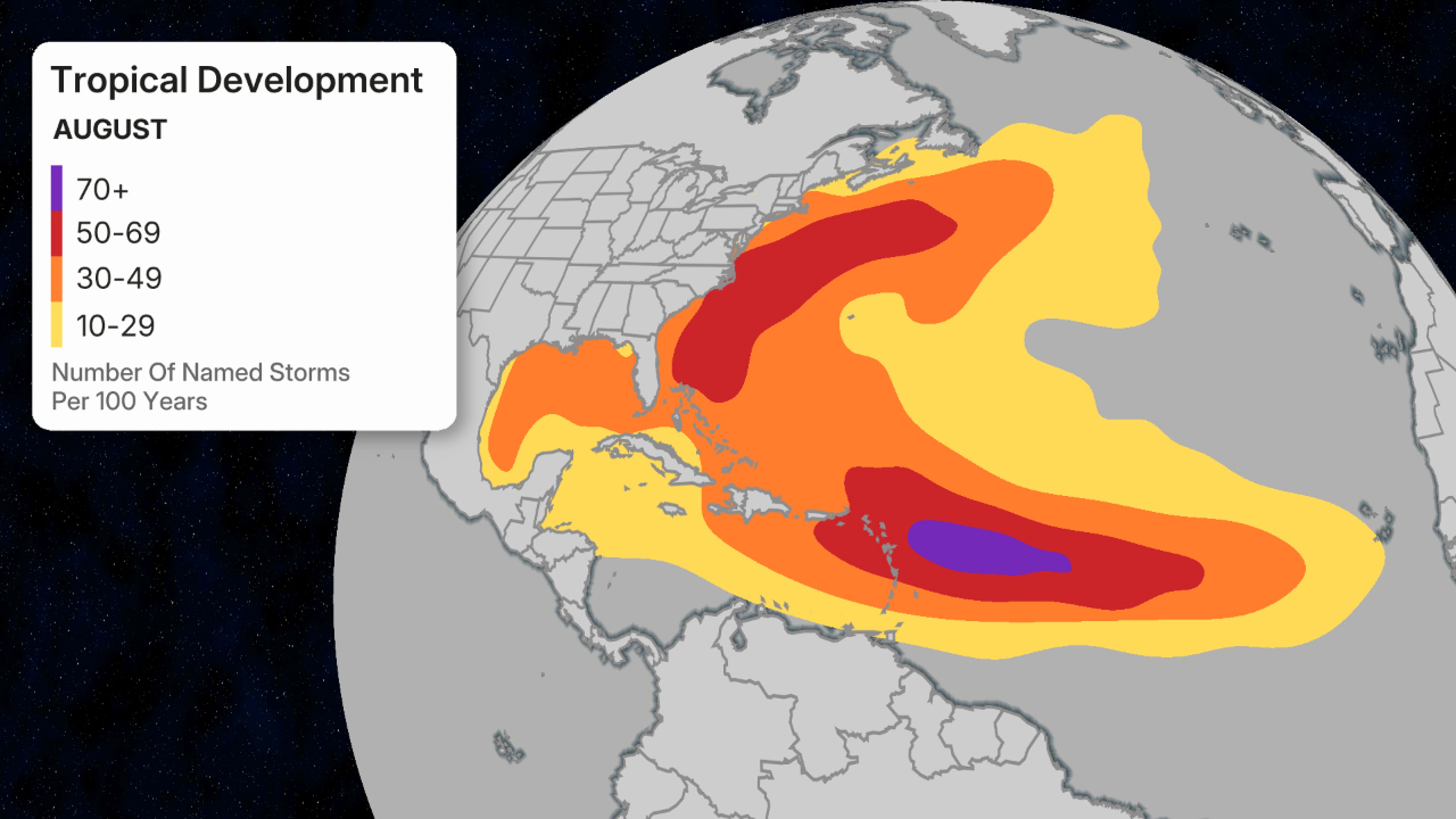
August’s favored named storm formation areas.
(Data: National Hurricane Center)
Jonathan Erdman is a senior meteorologist at weather.com and has been covering national and international weather since 1996. Extreme and bizarre weather are his favorite topics. Reach out to him on Bluesky, X (formerly Twitter) and Facebook.