Heat peaks with storms in the afternoon
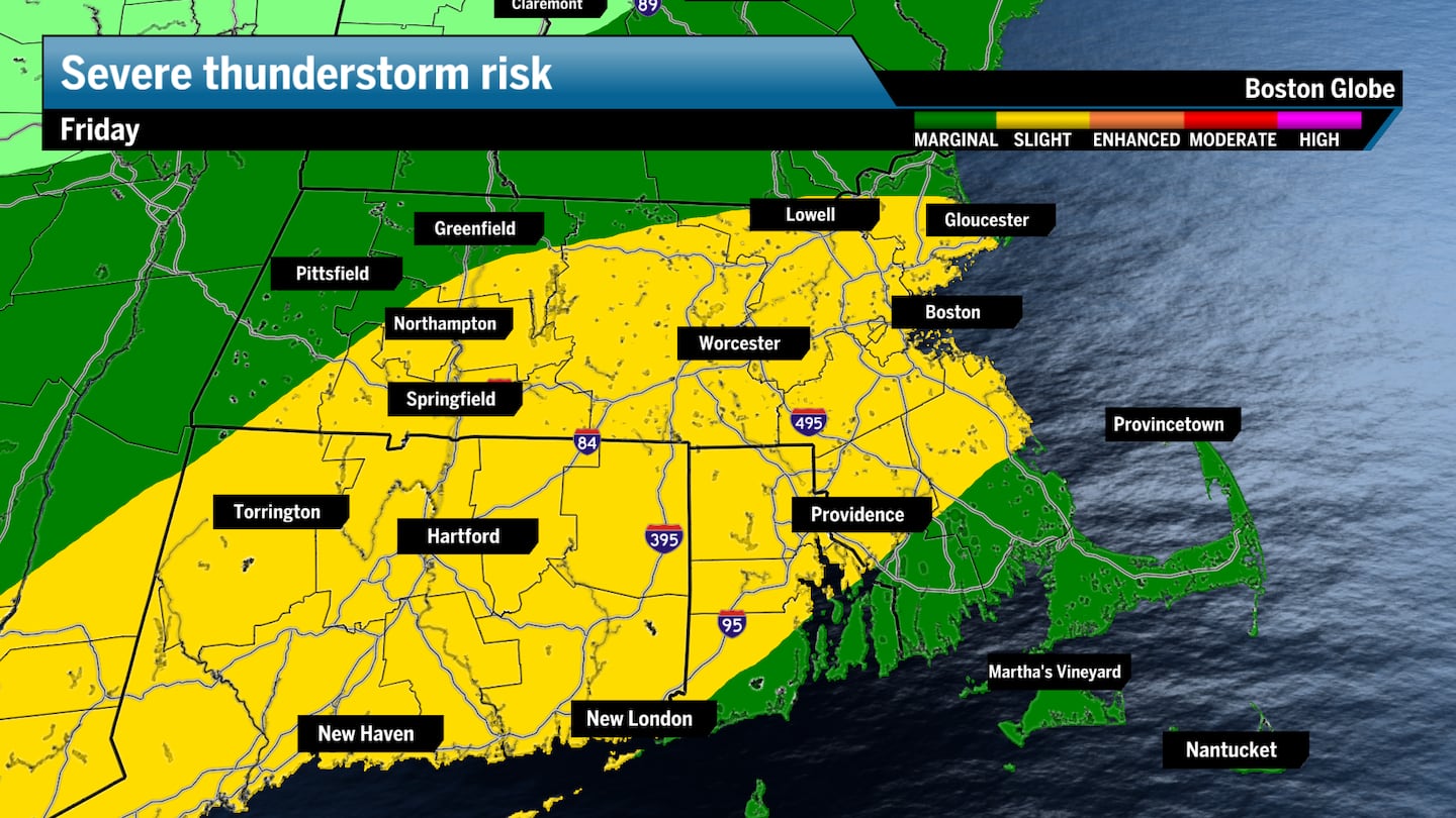
Storms began pushing through New England from the northwest early Friday afternoon, and are forecast to eventually bring scattered showers and thunderstorms to the Boston area, possibly into the evening commute. Some of the storms could be severe, with strong gusty winds, hail, heavy rain, and lightning forecast. Some localized flooding also may occur, so be careful when driving out there. The rising dew points and humidity are helping create this unstable atmosphere.

2 p.m. to 7 p.m. — Storms turn more dense and reach their peak strength while peak heating occurs across the region, pushing toward coastal New England and reaching the Boston and Providence region likely between 3 and 6 p.m. The Cape and islands may see storms closer to 7 p.m.
7 p.m. to 9 p.m. — A lingering shower may spoil a night out on the town, but things mostly clear out by the 9 p.m. hour as lows dip to the 60s overnight.

Scattered storms expected between 1–9 PM as a cold front moves through. Some could be strong to severe.
Hazards: damaging winds, heavy rain (localized flooding), small hail, and frequent lightning.
Plenty of outdoor events today—stay weather aware! ⛈️#MAwx #RIwx #CTwx pic.twitter.com/U0JVc2yuyT
— NWS Boston (@NWSBoston) July 25, 2025

The brief, but intense, burst of heat comes to a peak Friday, with highs in the mid-90s, as dominant high pressure sets to the south ahead of the cold front. The intense heat and humidity in the air have prompted widespread heat advisories as dew points in the 70s will make the heat index values jump into the 100s.
Some folks up north will likely reach the upper 80s or low 90s as clouds arrive earlier in the day to temper some of the heating. Boston’s daily record high for Friday is 96 degrees, set in 1882, which will likely be tied or broken.


Make sure you take breaks in the shade and hydrate if you are spending any extended time outdoors. And remember, don’t leave children or pets in vehicles and check in on the elderly and your neighbors, as heat-related health risks will be elevated across much of the region, especially in Boston.
The dew points will make it feel once again like South Florida, a common theme this summer as Boston is pacing one of the muggiest summers on record. The air will feel thick, and your body can overheat in a hurry if you’re not careful outdoors.

Some wind gusts could reach 50 or 60 miles per hour with heavy downpours.
The broken line of storms will make rain totals hit or miss, with some picking up a tenth of an inch while others total closer to a half inch. Locally higher amounts of an inch could be possible.
The heat subsides, with Boston set to see a beautiful day on Saturday as a quick pocket of high pressure settles in behind Friday’s front. Temperatures and humidity won’t drop like they did at the beginning of the week, but relief will be abundant across New England, with highs reaching the low to mid-80s under mostly sunny skies and a slight breeze. It’ll be a great day to spend outdoors.

Sunday will be a bit more unsettled as a wave of energy reaches the city and most of Southern New England. You can expect scattered showers and a few general thunderstorms, mainly during the afternoon. Northern New England isn’t completely in the clear, but folks up north have a better chance of staying drier than Boston and areas south.
Highs will remain in the low to mid-80s region-wide, except for the immediate New England coast.


Greater Boston: Hot and humid on Friday. Starting sunny, turning more cloudy in the afternoon. Highs to the mid and upper 90s with afternoon thunderstorms. Beautiful day on Saturday with mostly sunny skies and highs in the low to mid-80s. Sunday sees partly to mostly cloudy skies with highs to the low to mid-80s. Scattered showers are expected or a general thunderstorm, mainly in the afternoon.
Southeastern Mass.: A touch cooler but still hot. Highs to the mid-80s along the coast, low 90s inland. Afternoon showers and thunderstorms are expected. A beautiful start to the weekend. Mostly sunny skies are expected with highs in the low 80s. Mostly cloudy skies on Sunday with highs in the upper 70s to low 80s with a chance for a shower or two.
Central/Western Mass.: Hot and very muggy. Highs to the mid-90s, upper 80s in the Berkshires. Storms lurk beginning late morning west, and afternoon across Worcester County. A beautiful day on Saturday with highs in the mid-80s across the region under mostly sunny to completely blue skies. Seeing partly to mostly cloudy skies throughout Sunday. Highs still reach the mid-80s, with the Berkshires closer to 80 degrees. A couple of showers loom with a general thunderstorm chance.
Cape and Islands: Partly to mostly sunny with increasing clouds later on Friday. Highs to the low and mid-80s. Showers and a thunderstorm are possible in the evening. Seeing a great day to be on the Cape on Saturday, highs to the upper 70s under mostly sunny skies. Mostly cloudy on Sunday with the chance for a couple of showers. Highs to the mid and upper 70s.
Rhode Island: Hot and humid. Highs to the upper 80s and low 90s. Scattered showers and thunderstorms are expected throughout the afternoon. Sunny skies on Saturday with highs ranging from the low to mid-80s. Seeing partly to mostly cloudy skies on Sunday with a shower chance. Highs to the upper 70s and low 80s.
New Hampshire. North of Plymouth, you start with more clouds than sun, then flip south across Manchester and Concord. Highs spread from the low 80s to the low 90s north to south along the state. Scattered showers and thunderstorms are expected throughout the afternoon. Very nice Saturday on tap with highs to the upper 70s and mid-80s under mostly sunny skies. Partly to mostly cloudy skies statewide on Sunday with highs to the upper 70s and low 80s. A chance for a shower or two, especially in the southern portions of the state.
Vermont/Maine: Same as New Hampshire on Friday, with more clouds up north to cool temperatures a touch. The upper 80s and low 90s across the southern areas. Scattered showers and thunderstorms are expected mostly throughout the afternoon. Seeing lots more sunshine on Saturday with highs in the upper 70s and low 80s. Sunday brings a mix of sun and clouds, with more clouds in the afternoon. A chance for a shower or thunderstorm, especially south and in the afternoon.

Sign up here for our daily Globe Weather Forecast, which will arrive straight into your inbox bright and early each weekday morning.
Ken Mahan can be reached at ken.mahan@globe.com. Follow him on Instagram @kenmahantheweatherman.